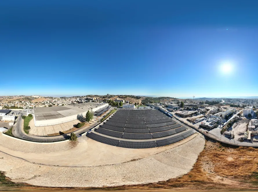
Drone-based stockpile measurement in Jordan delivers 2–3% volume accuracy in under an hour, replacing manual surveys that took half a day per pile and giving finance teams the monthly reconciliation reliability they need for audit. A single morning flight covers all stockpiles at a typical Jordan quarry, aggregate yard, or cement plant feed area.
Why stockpile measurement is finance’s number-one drone use case
Stockpile inventory is one of the largest line items on most quarry, cement, and aggregate balance sheets — and one of the hardest to verify monthly with traditional methods. Drone measurement makes monthly reconciliation routine instead of exceptional, tightening the gap between booked and physical inventory.
How drone stockpile measurement works
A drone flies a pre-programmed grid over each pile, capturing overlapping images. Photogrammetry software reconstructs a 3D surface, computes volume against a flat or known base, and produces a per-pile volume number. With ground control points, accuracy reaches 2–3% — well within audit tolerance.
Typical accuracy and what affects it
Accuracy depends on flight altitude, overlap percentage, ground control points, and surface texture. Fine-grain aggregates and consistent texture are best. Smooth surfaces (sand, fine powder) require extra GCPs. We size each flight to your accuracy target.
How fast is a typical drone stockpile survey
A drone flight covering 5–10 stockpiles typically takes 30–60 minutes. Processing and report delivery is 1–2 working days. Compared with manual GPS-rover surveys (half a day per pile), the throughput improvement is roughly 5–10x.
Monthly reconciliation as a service
Most Jordan operators move to monthly drone surveys once they see the first month’s reconciliation gap. A regular monthly contract carries a discounted day-rate and produces a consistent month-on-month delta report, helping finance and operations align faster.
What the report contains
Each survey delivers: per-stockpile volume in m³ and tonnes (using a client-supplied density), a comparison against the previous month, a colour-coded change map showing where each pile moved, and an accuracy report with GCP residuals.
Stockpile measurement — drone vs manual
| Factor | Drone | Manual GPS / total station |
|---|---|---|
| Time per pile | 3–6 min flight | 2–4 hours |
| Accuracy | 2–3% | 1–2% (if done well) |
| Safety | No surveyor on pile | Surveyor walks pile |
| Re-survey frequency | Monthly easily | Quarterly typical |
| Cost per survey day | Lower | Higher (labour) |
Frequently Asked Questions
How accurate is drone stockpile measurement?
Typically 2–3% volume accuracy with ground control points — well within audit tolerance. Some surface types (coarse aggregate) achieve closer to 2%; smooth fines need extra GCPs.
How long does the survey take?
30–60 minutes of flight time for 5–10 stockpiles, plus 1–2 working days for processing and report delivery.
Can drones survey active yards?
Yes — we fly during normal yard operation, coordinating with operations to avoid haul-truck and loader zones. No production halt needed.
How often should we survey?
Monthly is the sweet spot for most Jordan operators. The first monthly reconciliation usually reveals enough to justify the recurring cost.
Can the report integrate with our ERP?
Yes — we deliver volumes as CSV with stockpile IDs, ready to import into SAP, Oracle, or your custom ERP.
Work With Loyalty Drones
Need monthly stockpile reconciliation? Contact Loyalty Drones for a free quote. Related reading: mine surveying & site assessment by drone in Jordan. drone services in Jordan.