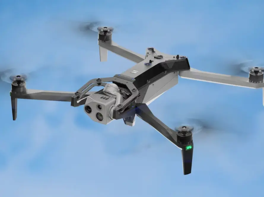
The landscape of commercial drone technology is constantly evolving, but every so often, a platform emerges that genuinely redefines capabilities. The DJI Matrice 400 (M400), DJI’s newest flagship enterprise drone, is precisely such a game-changer. Engineered for the most demanding industrial applications, the M400 is not just an incremental update; it’s a significant leap forward in endurance, payload versatility, and intelligent operation. For businesses in Jordan and across the MENA region seeking to optimize their operations in surveying, inspection, public safety, and more, the M400 represents a formidable tool for efficiency, safety, and precision. Loyalty Drones, a leader in aerial technology solutions, dives deep into what makes the M400 the right choice for your critical missions.
Key Features: A Deep Dive into Enterprise Excellence
The M400 is packed with innovations designed to tackle complex industrial challenges. Here’s a closer look at its standout features:
Unprecedented Payload Capacity and Versatility
One of the most striking upgrades in the M400 is its expanded maximum payload capacity of 6 kg (13.2 lbs). This is more than double the 2.7 kg capacity of its predecessors, the M350 RTK and M300 RTK. This significant increase unlocks a new realm of possibilities for carrying heavier and more advanced multi-sensor configurations simultaneously.
The M400 boasts four external E-Port V2 interfaces and can support up to seven payloads simultaneously using various gimbal connectors. This unparalleled versatility means operators can quickly switch between different mission requirements—from high-resolution photogrammetry with the Zenmuse P1, to advanced thermal and visual inspections with the Zenmuse H30T, or precise LiDAR mapping with the Zenmuse L2. This modularity drastically improves mission readiness and operational efficiency by reducing the need for payload swaps and reconfigurations between tasks.
Extended Flight Time and All-Weather Performance
Endurance is paramount for enterprise missions, and the M400 delivers. With a maximum flight time of 59 minutes (measured with a single H30T, L2, or P1 payload), it surpasses the M350’s 55 minutes, providing nearly an hour of effective operational time. This extended endurance allows for covering larger areas, completing longer inspection routes, and reducing the number of battery swaps required for extensive projects.
Designed for demanding environments, the M400 features an IP55 rating, ensuring protection against dust and rain. Its robust construction allows it to operate reliably in extreme temperatures ranging from -20°C to 50°C (-4°F to 122°F), making it suitable for year-round operations in diverse climates, including the challenging conditions often found across Jordan.
Advanced RTK and Intelligent Mapping Tools
The Matrice 400 integrates Real-Time Kinematic (RTK) technology, offering centimeter-level positioning accuracy for high-precision surveying and mapping. When paired with payloads like the Zenmuse P1 for photogrammetry or Zenmuse L2 for LiDAR, the M400 streamlines data collection for highly accurate 2D orthophotos, 3D models, and point clouds.
New intelligent mapping tools significantly enhance efficiency:
- Real-Time Terrain Follow: Supports both manual and route-based missions, maintaining ground-relative height in any direction, ensuring optimal data acquisition even over varied topography.
- Intelligent Power Line-Following Missions: With the Zenmuse L2, the M400 can perform smart power line inspections, detecting and bypassing crossing or intersecting wires in real-time.
- Slope and Geometric Path Planning: For complex environments, the M400 can plan oblique and geometric flight paths, ideal for high-efficiency data capture in dense urban areas or sloped terrains.
Revolutionary Obstacle Sensing and Safety Systems
Safety is at the core of the M400’s design. It introduces an advanced, multi-sensor obstacle avoidance system that significantly enhances operational safety and confidence:
- Rotating LiDAR: Provides continuous 360-degree scanning, capable of detecting thin wires (as small as 21.6 mm) at flight speeds up to 25 m/s.
- mmWave Radar: Embedded in all six directions, this radar adds redundancy, detecting obstacles in challenging conditions like rain, fog, or dust, where optical sensors may struggle.
- Full-Color Low-Light Fisheye Vision Sensors: Six fisheye cameras provide real-time visual situational awareness and obstacle detection even at night, automatically switching to black-and-white imaging below 12 lux for clarity.
- AR Powerline Warning: Overlays clearly visible AR lines on the remote controller screen to warn operators about overhead power lines, even in complex environments.
- O4 Enterprise Transmission: Offers an extended transmission range of up to 40 km (FCC), double that of the M350’s O3 Enterprise system, ensuring robust and stable 1080p/60fps video transmission, even in electromagnetically noisy environments. It also supports dual 4G dongles for network redundancy and an airborne relay for signal extension.
Industry Applications: Where the M400 Shines
The M400’s advanced capabilities make it an indispensable tool across a wide array of enterprise sectors:
Surveying and Mapping
For land development, construction, and topographic surveys, the M400, especially when equipped with the Zenmuse P1 or L2, delivers centimeter-grade mapping accuracy. Its extended flight time allows for large-area coverage, reducing field time significantly. Features like Real-Time Terrain Follow and sophisticated flight path planning (including for slopes and complex geometries) ensure high-efficiency data collection for comprehensive site surveys, volume calculations, and digital twin creation. This aligns perfectly with Daniel Qura’s focus on geospatial mapping, land surveying, and urban planning.
Infrastructure Inspection
The M400 is a powerhouse for inspecting critical infrastructure such as power lines, pipelines, bridges, wind turbines, and telecommunication towers. Its high payload capacity can accommodate multiple sensors, including the Zenmuse H30T (with high-zoom, thermal, and laser rangefinder) and the Zenmuse L2 LiDAR for detailed structural analysis. The advanced obstacle avoidance system, particularly the thin-wire detection, ensures safe operations around complex structures. Its extended flight time allows for long-corridor inspections with fewer battery swaps, significantly increasing operational efficiency for utility companies and asset management firms.
Public Safety and Emergency Response
In critical situations, the M400 acts as a force multiplier for public safety, law enforcement, and emergency management teams. Its long flight time, robust transmission, and all-weather capability ensure rapid deployment and continuous situational awareness. Payloads like the Zenmuse H30T provide essential thermal imaging for search and rescue operations, while the Zenmuse S1 Spotlight and Zenmuse V1 Speaker enable nighttime illumination and real-time communication for crowd control or delivering critical instructions. Intelligent features like Smart Track (for automatic tracking of vehicles or individuals) and Real-Time Terrain Follow enhance operational effectiveness during disaster response, crime scene mapping, and tactical monitoring.
Comparison: M400 vs. M350 RTK / M300 RTK
While the Matrice 350 RTK (and its predecessor, the M300 RTK) are highly capable enterprise drones, the M400 represents a significant generational leap.
The M400 is clearly positioned as the superior platform for organizations demanding the highest levels of performance, safety, and versatility for their drone operations
Conclusion: Is the DJI Matrice 400 the Right Tool for Your Business?
The DJI Matrice 400 is not just a drone; it’s a comprehensive aerial intelligence platform designed to address the complex needs of modern enterprise. Its extended flight time, significantly increased payload capacity, unparalleled obstacle avoidance systems, and advanced intelligent features set a new benchmark for industrial drones.
For businesses and government entities in Jordan and globally engaged in large-scale mapping, precise inspection of critical infrastructure, or time-sensitive public safety operations, the M400 offers unmatched efficiency, safety, and data fidelity. While the initial investment is substantial (with the drone alone starting around $10,973.00 USD, and payloads adding significantly to the cost), the return on investment through reduced operational time, enhanced data quality, and improved safety protocols makes it a compelling choice for organizations looking to future-proof their aerial capabilities.
At Loyalty Drones, we are experts in deploying advanced drone solutions for businesses across the MENA region. We can help you assess whether the DJI Matrice 400 is the ideal fit for your specific operational requirements, offering consultation, integration, and training to ensure you maximize its incredible potential.
Elevate your enterprise operations with the power of the DJI Matrice 400.